mountains

Your Guide to Denali National park

For National Park enthusiasts, Denali is one to check off the bucket list. I recently spent 4 months in the Alaskan Interior, and visited Denali 4 times. Between understanding the park road, wildlife viewing, and the best times to see The Mountain, this is your guide to everything you need to know to visit Denali National Park.

Why Visit Denali?

Denali is known as Alaska’s Yellowstone. It is a vast, incredible, open landscape that is mostly closed to vehicular traffic, making it one of the most pristine wildernesses you can drive to. Because of its untouched wild, it makes for an incredible space for healing, meditation, and being with oneself if you are on a pilgrimage pack to yourself. If you’re simply looking for an incredible place to experience the beauty of Alaska’s nature, there is no shortage of that, either. Denali is home to endless wildlife, the tallest mountain in the US, and incredible backcountry experiences you can’t get anywhere else.

This post was written in 2021, so rules may have changed if visiting in future seasons. For the most part, these systems are the same year to year.

Horseshoe Lake Loop Trail

Horseshoe Lake Loop Trail

When is the best time to go?

There are only two distinct seasons of visitation in Alaska: Summer and Winter. Of course, there are their versions of spring and fall, deemed the Breakup and the Freeze-up, but most people don’t visit during those periods. Denali is open year round, but unless you’re prepared for sub-zero temperatures, and getting around via dogsled, you’ll want to visit in the summer. Summer season in Alaska lasts from around June 1 to September 15. Businesses usually open around May 15, but some roads are still snowy then.

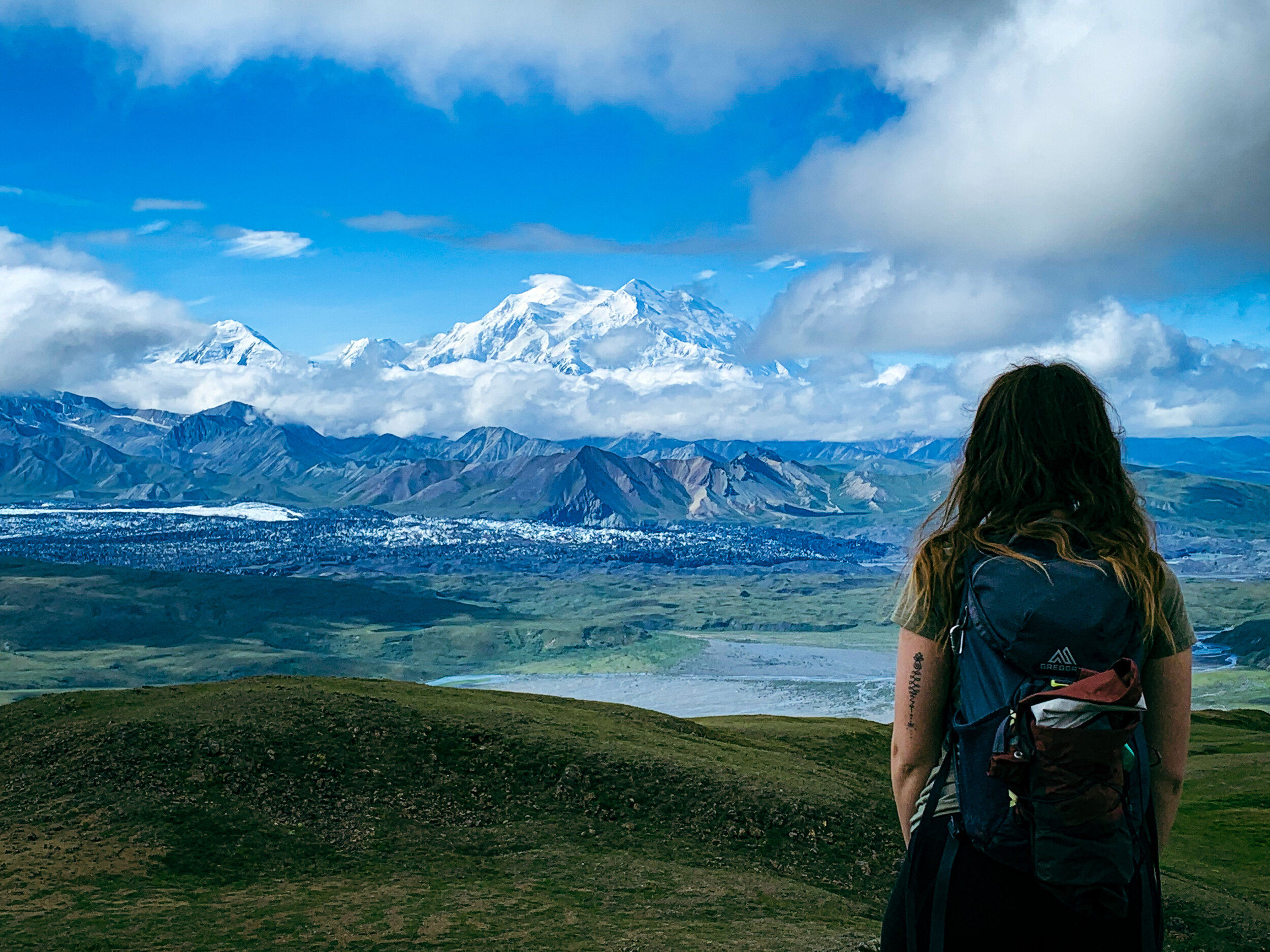
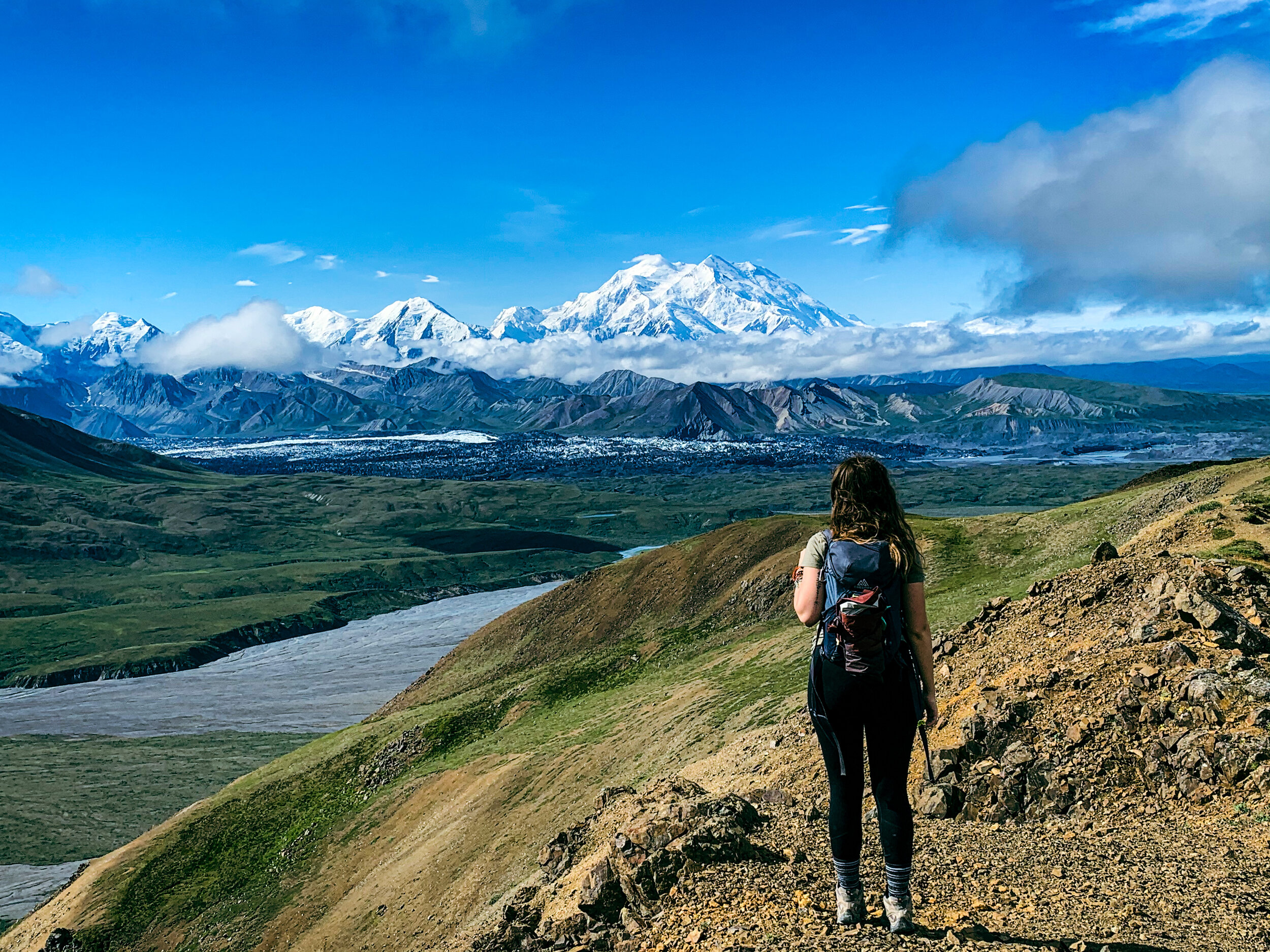
When it comes to visiting Denali, be prepared to become part of the “70% club.” Only 30% of visitors actually see the Mountain, and your best chances are to go in late June or July, and enter the park as early as possible. You’ll want to hop on a bus to Eielson for your best chances of getting a picture like the one below!

Can I drive to Denali?

This is a complicated question because the short answer is, yes, you can drive to the park. Due to protections instated by the National Park Service, though, you can only drive up to Mile 15 of the Park Road. You’ll be able to get to the visitor center, a few established trails, the bus depot, and your furthest point: Savage River. There are very low chances of getting to actually see Mount Denali from this section of the road, so if you don’t have bus reservations, I suggest visiting the local State Park as well, to try to catch a view of it from the North or South Viewpoints.

The Savage Alpine Trail, one of the established trails accessible from the first 15 miles of the Park Road

The Savage Alpine Trail, one of the established trails accessible from the first 15 miles of the Park Road

How does the bus system work?

The bus system is the only way to explore the park past mile 15. You must have a reservation ahead of time, which you can make through Reserve Denali. There are three types of buses you can reserve: Camper Buses, Transit Buses, and Tour Buses. Exceptions to this include buses going to Kantishna Lodge, and standby tickets only available for campers spending 3 nights or more at Teklanika River Campground.

Camper Buses are only for backpackers and campers staying in one of the Park’s many established campgrounds. These buses can take you to a campground, or drop you off in one of the Park’s backpacking regions.

Transit buses can take you through the park, usually as far as the Eielson Visitor Center. In past years, they were able to take you to Wonder Lake, but as of 2021, Wonder lake was only for campers. Transit buses are not required to give you park information, but are a great way to get to see wildlife, and drive through the park.

Tour buses have to give park information as they drive you through the park, but generally stop before Eielson. So if you want to get all the way to the visitor center, I’d suggest booking a Transit bus.

Due to landslides at Polychrome, the park road became inaccessible at the end of the 2021 season until the park finishes construction on this part of the road. The landslides were caused by melting permafrost. Please contact Reserve Denali to check road conditions before booking your bus ticket.

IMG-9439.JPG

What are the best hiking trails?

Denali is mostly a free-hike park, meaning you can go anywhere you want in approved areas, without an established trail. If you choose to do this, make sure you’re confident in your navigation skills, and carry a topographical map of the area you’re going to be hiking.

Always carry bear spray when hiking in Alaska.

The established trails that do exist in Denali are generally short, and many of them are located before Savage River on the park road. In this area, the Savage River and Savage Alpine trails are popular, and the Roadside Trail is the only official dog friendly trail in the park. For a trail close to the park entrance, check out the Horseshoe Lake Trail.

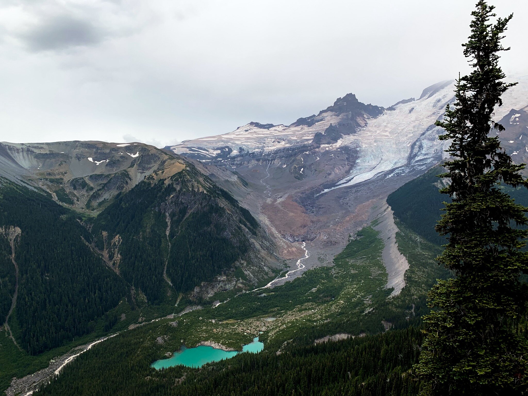
Some of my favorites though, are in the Eielson area, including Thoroughfare Ridge Trail, pictured above.

Looking for more information or local conditions? Check the National Park Service Website!

Your Guide to Yosemite National Park

Yosemite is one of the Big Three National Parks in the US, with Yellowstone and the Grand Canyon being the other two. It’s a top tourist attraction in California, and it’s the site of documentaries such as Free Solo, The Dawn Wall, and Valley Uprising. It’s a rock climber’s paradise, and it’s home to huge rock monoliths such as El Capitan and Half Dome. It’s a destination that’s on nearly everyone’s bucket list, but if you’ve never been, it’s quite an overwhelming park to plan a trip to. This is your complete guide, to help you plan your Yosemite camping trip, vacation, or something in between.

IMG_3073.jpg

The Basics

Yosemite is located in Northern California, and is closest to Sacramento. It spans over 1,200 square miles. It’s most easily accessible from the west entrance. The east entrance through Tioga Pass closes for snow between November and May/June. It costs $35 to enter per car, or the use of an America the Beautiful Pass. You will need a car to get from the entrance station into the Valley, but in a normal operation year, there is a shuttle you can take around the park. Overall, pets are not allowed on trails, but please check NPS.gov/yose/planyourvisit/pets for more information on where your dog can accompany you so that you can make the decision of whether you want to bring your dog with you to the park.

IMG_2542.jpg

What time of year should I visit?

Yosemite is known for its waterfalls (Yosemite falls is the tallest waterfall in the lower 48), so if your goal is the see the falls, spring is going to be your best bet, after the snowmelt. But, that’s not to say that other times of the year aren’t amazing times to visit. Winter is ideal for avoiding crowds, but the park does get super snowy. Winter is also the only time of year you can see the annual Fire Fall at Horsetail Falls (February). Summer will be the warmest but also the most crowded season, however, it’s not too late to see the waterfalls this time of year. In the Fall, the waterfalls are mostly dried up, but this is the only time of year that you can see the trees changing colors, which is a unique sight to see in this park.

IMG_3057.jpg

Where should I stay?

If your goal is to stay in the park, you’ll have quite a few choices. If you want to camp in the park, I suggest making reservations on Recreation.gov as soon as you start planning your trip. Upper Pines is my favorite reservable campground in the park, but any of them will do. If you can’t get a camping reservation, I love the community at the walk up campground Camp 4. This is the famous climber’s camp, and it’s only $6 per person.

If you’re not super into camping, there are quite a few lodging options within the park. The Ahwahnee, the Yosemite Valley Lodge, and the Wawona Hotel are three hotel options within the park. If you want a glamping experience, Housekeeping Camp or Curry Village are great options.

If you can’t get a spot in the park, there are plenty of hotels and even a hostel in the nearby town of Oakhurst.

IMG_2541.jpg

What should I not miss?

When people ask me this question about Yosemite, I have a list of my go-to spots for first time travelers. If you’re entering the park from the west side, make sure you make a stop at Glacier Point on your way either in or out of the park. Once you’re in the Valley, make sure you see Lower Yosemite Falls, and if you’re a hiker, hiker to Upper Yosemite Falls. If you visit in the Spring or Summer, make sure you go see Mirror Lake. Seeing the giant Sequoias in the Mariposa Grove is a must-see for anyone who’s new to the Sierra Range. For hikers, Vernal and Nevada Falls are a great combo of hiking destinations to fill a day with. Of course there is so much to see in the park, but if you can’t fit anything else, make sure you catch the sunset over Half Dome one night.

IMG_3110.jpg

Anything else?

Yosemite is home to tons of wildlife, so to keep them and you safe, make sure that you use bear boxes whenever camping, and try not to leave food in your car. Yosemite bears are smart and can break into vehicles. Bear spray is not necessary in the park, unless it makes you feel better, since there are no grizzlies in Yosemite, but they do want your food, so make sure you don’t sleep with anything in your tent that smells like food.

Also, remember that no national park is an amusement park, so you’re responsible for your safety on the trail, your food, and to keep your area clean of all trash. Wear proper footwear when on the trail, and bring water, even if it’s cold outside.

Top 5 Underrated Destinations of 2020

Despite 2020’s strange circumstances when it came to travel, the magic of vanlife is that I still got to see quite a bit of the country. We passed through more than 15 states on our way from California to Kentucky, between mine and my boyfriend, Jared’s family. Even though we dealt with COVID-19 closures, restrictions, and stress, there were still quite a lot of places that truly stood out to me. I have a whole list of places I’d love to return to one day, but I’ve complied my top 5 underrated destinations for you to add to your list for future travel.

Ranch horses in the Alabama Hills

Ranch horses in the Alabama Hills

The State of Idaho

Idaho is seriously one of the most underrated places in this country. From unexpected mountain ranges to flowing waterfalls to abundant hot springs, Idaho has natural beauty around every corner. Idaho is located in the west, in between Oregon and Washington on the coast and Montana and Wyoming inland. It’s known for its potatoes but it is so much more than that!

City of Rocks, ID

City of Rocks, ID

Places worth seeing:

·       Sunbeam Hot Springs

·       Stanley

·       The Sawtooth Mountains

·       City of Rocks National Reserve

·       Craters of the Moon National Monument

Sawtooth Mountains, ID

Sawtooth Mountains, ID

Badlands National Park, SD

This is an interesting one because I actually visited the Badlands in 2019 too, but didn’t like them nearly as much as I did this time. I recently wrote a whole post on the Badlands so I don’t feel like I need to go into too much detail, but the Badlands are spectacular. They are located in western South Dakota, and are home to animals such as coyotes, pronghorns, bison, prairie dogs, big horned sheep, and more.

Badlands10.JPG

Places worth seeing:

·       Yellow Mounds

·       Roberts Prairie Dog Town

·       Toadstool Rock

Badlands9.JPG

Alabama Hills, CA

The Alabama Hills were actually the first place we chose to live during quarantine in the vans. Located just outside of Lone Pine, CA in the Eastern Sierras, the Alabama Hills are located on BLM Land, which means free camping, lots of hiking and climbing, and stunning views. The Alabama Hills are known as the “Whitney Portal—” the gateway to Mount Whitney, the Lower 48’s tallest mountain. Because of that, you’ll get both desert rock formations and mountain views when you visit this iconic spot.

AlabamaHills1.JPG

Places worth seeing:

·       Mobius Arch

·       Whitney Portal (drive or hike to the Whitney trailhead, depending on the time of year. If you’re up for it, and the trail isn’t snowed over, it’s 11 miles one way to the summit!)

·       Death Valley (This famous National Park is only an hour away and worth the day trip)

Hiking the road up to Whitney Portal

Hiking the road up to Whitney Portal

Crested Butte, CO

We spent about a month in Colorado, and while I loved so much of the state, Crested Butte will always stand out to me as my favorite. Famous for being a ski town in the winter, Crested Butte is surrounded by mountains such as Gothic Peak and Crested Butte itself. This area is home to some incredible wildlife such as elk and bears, and mountains that resemble those of Glacier National Park. This is the first place I heard an elk bugle, so in the fall, make sure you keep an ear out!

CrestedButte2.jpg

Places worth seeing:

·       Gothic Peak Trail (even if you don’t make it to the top, the views are pretty incredible)

·       The town itself (the town of Crested Butte is adorable and reminded me of places like Telluride)

·       Crested Butte (this towering formation is hard to miss, and you can hike or bike to the top if that’s your thing)

CrestedButte1.jpg

Mount Hood National Forest, OR

I’d wanted to visit Mount Hood for a really long time, but I didn’t realize how incredible it would really be. This is a place to climb mountains, swim in lakes, dip your toes in an ice river, and camp with a view! Mount Hood is easily my favorite National Forest in the country, only rivaled by the Sawtooth and Wind River Wildernesses. Mount Hood is also full of waterfalls, stunning pine trees, and dog friendly trails.

Trillium Lake

Trillium Lake

Places worth seeing:

·       Trillium Lake

·       White River

·       Cooper Spur (if you feel like climbing a mountain)

·       Timberline Lodge

·       Tamanawas Falls

Tamanawas Falls

Tamanawas Falls

While 2020 wasn’t the adventure we thought it would be, that doesn’t mean there wasn’t plenty to be seen. How many of these places have you visited? How many are on your bucket list?

A Visitor's Guide to Mount Rainier National Park

Home to three National Parks, Washington State is a nature-lover’s dream destination. From the sprawling mountains of the North Cascades to the hidden rainforest of Olympic, there’s something for everyone in this Pacific Northwest state. But there’s one National Park that stands out as a crowd favorite when it comes to Washington, and that’s Mount Rainier.

Mount Rainier is the most glaciated mountain in the lower 48. This park stays cold well into the summer months, and attracts visitors of all ages to come and explore its forests, climb to its peak, and discover its secret lakes and waterfalls created by snowmelt. In the summer, you can spot beautiful wildflowers and incredible wildlife as you explore the park, and still experience the same snowy landscapes as winter visitors in some areas of the park.

We recently spent the holiday weekend in Mount Rainier and explored the best areas of the park. Here is my guide to help you plan your visit.

The view from an overlook accessible from a trail near the Sunrise Visitor Center.

The view from an overlook accessible from a trail near the Sunrise Visitor Center.

First things first…

Mount Rainier is located about 2 hours south of Seattle, WA, and is bordered by the Mt. Baker-Snoqualmie and Gifford-Pinchot National Forests. These areas are home to animals such as black bears, marmots, elk, and deer, so be on the lookout for any creatures as you drive through the park!

The entry fee for Mount Rainier is $30 per vehicle or the America the Beautiful Pass. During COVID-19, Mount Rainier is doing fee collection.

Pets are allowed to join you during your visit, but they are limited to certain areas of the park, such as parking lots, campgrounds, and picnic areas. There is a dirt road in the Sunrise section of the park where you can walk your dog. Dogs are not permitted on park trails.

There are two campgrounds in the park, White River and Ohanapecosh, but there are also tons of boondocking and dispersed camping spots in the nearby forests.

Mount Rainier National Park

Mount Rainier National Park

Sections of the park

There are five main sections of the park: Ohanapecosh, Longmire, Paradise, Sunrise, and Carbon River. Each section has something unique to see and do.

In Ohanapecosh, experience old growth forests, deep canyons, and gorgeous views! We didn’t spend too much time in this section because the road was closed ten miles in due to winter damage.

The Longmire area leads into Paradise, which is the subalpine area in the southern end of the park. Longmire is where the park’s founders stayed during their time in the area, so this is an important area to stop and experience on your way up to the subalpine!

On the way from Longmire to Paradise there are plenty of amazing views to see!

On the way from Longmire to Paradise there are plenty of amazing views to see!

In Paradise, you’ll find yourself up next to the mountain. Here, you’ll be able to experience the subalpine in the southern side of the park, much of which stays snowy well into summer. Here, we were able to do the Nisqually Vista Trail, a small snow hike that leads to a glacial view of Nisqually Glacier.

The Carbon River section is located in the Northwest corner of the park, and is known for being the park’s temperate rainforest. This area is generally cool and rainy, and is a great place to experience some of the most unique Pacific Northwest landscapes.

Mount Rainier is perfect for solo travelers looking to get out of their comfort zones!

Mount Rainier is perfect for solo travelers looking to get out of their comfort zones!

Sunrise is our personal favorite section of the park. Here, you’ll reach elevations of 6,400 feet and might meet animals like black bears and marmots. Here, there are plenty of hiking trails that are accessible in early summer, despite the snow, just make sure that you know your hiking level! This is one of the best places to see Emmons Glacier.

Sunrise at Sunrise Point is an incredible experience

Sunrise at Sunrise Point is an incredible experience

Best underrated things to do

While Mount Rainier is known for hiking and mountaineering, there are plenty of really underrated things to experience! These are our favorite things we did during our time in the park.

Get up for sunrise… at Sunrise

Sunrise in the PNW is incredibly early, but you’ll never experience a sunrise like the ones from Sunrise Point in the park. Here, you’ll be above the clouds and get incredible and almost private views of Mount Rainier as soon as the sun comes up. In early July, we got up at 4:30 to drive from the park entrance to Sunrise Point for sunrise at 5am.

A secret no-name lake in Mount Rainier National Park with the famous mountain hiding behind some clouds

A secret no-name lake in Mount Rainier National Park with the famous mountain hiding behind some clouds

Search for hidden waterfalls and lakes

While it is still a hike, it’s not a long one to find the best secret lake and waterfall. The Glacier Basin Trail that starts in White River Campground is home to tons of small yet beautiful waterfalls, and if you’re brave enough, a secret glacial lake with no official name that might take a little bit of effort to find!

Drive up to Tipsoo Lake

This part of the park is free to visit and has an beautiful reflective lake perfect for catching views of Mount Rainier, experiencing some July snow, and having a picnic in the picnic area. The drive up here also has views that can’t be beat!

The view of Mount Rainier from Tipsoo Lake in July

The view of Mount Rainier from Tipsoo Lake in July

Mount Rainier is truly an incredible National Park to visit, and easily the best in the state of Washington. Home to one of the tallest mountains in the country, this is a site that can’t be missed during your time in the Pacific Northwest. From wildflower to wild animals, to awakening your own wild self, Mount Rainier is sure to give you experiences you won’t soon forget.

The Best Things To Do In Mount Hood, OR

Mount Hood is easily the most prominent and famous mountain in the state of Oregon. It stands tall, and is visible from even areas south of Portland. It is an active volcano in the Cascade Volcanic Arc, and it is home to glaciers such as Elliot Glacier, meaning there is snow on the mountain year round.

I first laid eyes on Mount Hood in 2017, when I made my first visit to Oregon for the solar eclipse. If you are in Portland, one of the best places to see Mount Hood is from Pittock Mansion, which has an overlook that allows you to see the entire city and this giant mountain. But, you can actually get very close to Mount Hood itself, by visiting the National Forest, and surrounding areas. Mount Hood National Forest is public land, run by the USDA. For more information on what this means, click HERE.

I absolutely loved my time in Mount Hood National Forest. The views are spectacular, and there’s definitely more to do in Mount Hood than just look at this stunning mountain. Here are my top 4 things to do in Mount Hood, Oregon.

1: Chase Waterfalls

Because of all the snow runoff from the mountain, there are actually quite a few absolutely stunning waterfalls to view in the area. While they do often require a short hike, all of them are family friendly and dog friendly. My favorites were Umbrella Falls and Tamanawas Falls.

Tamanawas Falls is incredibly impressive, and the entire hike is only about 4 miles out and back. But be prepared for crowds, and bring something waterproof—you can walk behind the falls but you might get a little wet!

Tamanawas Falls, Mount Hood, OR

Tamanawas Falls, Mount Hood, OR

2: Visit Trillium Lake

Trillium Lake is famous for a reason—it’s home to some of the best views of Mount Hood. This popular spot is home to a hiking trail, campground, and plenty of space for swimming, floating, and enjoying the lake. Trillium Lake quickly became a favorite of mine—the views are unrivaled, and we found ourselves wishing we had a paddleboard so we could head out onto the water ourselves.

There is a day use fee of $5 per vehicle at Trillium Lake, and it is cash only.

The view of Mount Hood from Trillium Lake is one that can’t be beat!

The view of Mount Hood from Trillium Lake is one that can’t be beat!

3: Visit the Historic Timberline Lodge

I know what you’re thinking: what’s so special about a lodge you aren’t staying at? The Timberline Lodge is actually where Stephen King got the inspiration for the Overlook Hotel in The Shining, making this one of the most popular things to do in Mount Hood. The architecture of the lodge is also stunning to look at, and in the winter, it is home to one of the most popular ski slopes in the state.

Outside of the Historic Timberline Lodge! Go inside for some spooky Stephen King vibes!

Outside of the Historic Timberline Lodge! Go inside for some spooky Stephen King vibes!

4: Hike!

It’s almost impossible to visit a mountain and not hike at least a little bit. Hiking is one of the most popular things to do in Mount Hood mostly because of its stunning landscape and diverse trails. There were two trails we did in the area that were definitely on the harder side, but bring you closer to the mountain than ever.

The first one we did starts at the White River Sno Park and goes to the base of Mount Hood. You can even drop down toward the river at the end and dip your toes in its ice cold water! We decided to walk along the river for most of this journey, which is not part of the official trail, but there is a more solid trail that starts from the parking area right behind a gate on what appears to be an unmaintained dirt road.

The other hike we did is one that I wouldn’t even rate difficult—it is for advanced hikers (and dogs) only! Cooper Spur is essentially the side of Mount Hood itself, and currently the only way to access it is by hiking 5.15 miles to the top, climbing over 4,600 feet of elevation. The entire hike is 10.3 miles, and the last section involves snowy passes, high winds, and scrambling over volcanic sand and rocks. This is easily one of the hardest hikes I’ve ever done, but one of the most rewarding. Do not underestimate it, though—this hike is not something to mess with! But, if you aren’t quite there yet in your hiking level, don’t fret! You can get amazing views from only doing the first half of the hike too. The trail is marked by an A Frame shelter, which serves as the halfway point on the trail at about 2.7 miles and 2,000 feet of elevation gain. You will still get to see Mount Hood on your way up, and on a clear day, views of Mount Adams and Mount St. Helens in the distance. If you do make it to the alpine section on the second half of the hike, though, you will get close up views of Elliot glacier.

On the way to Cooper Spur, the smaller mountain-shape on the left!

On the way to Cooper Spur, the smaller mountain-shape on the left!

Mount Hood is one of my favorite places in Oregon by far. From the mountain’s stunning beauty to endless waterfalls to chase, this is a spot you absolutely can’t miss during your next trip to Oregon. Even just a drive through the Forest will give you beautiful views of the mountain you won’t find anywhere else!

If you have any questions about visiting Mount Hood or planning a PNW or West Coast road trip, head on over to my Patreon, where you’ll get access to resources that will help you plan your ultimate road trip!

Where To Go This Summer to Beat the Crowds

With so many people planning domestic travel for 2020, an overwhelming amount of travel questions these days have to do with road tripping. It seems to be the method of travel people are preferring this summer, with air travel feeling simply out of the question. No matter what, a road trip full of National Parks might sound incredibly enticing.

Disclaimer: this post may contain affiliate links

As someone who lives full time on the road, I’ve been able to see the world of road travel evolving with COVID-19 firsthand. And with Parks reopening, it’s becoming clear that some parks are going to be far more crowded than others.

Getting outside this summer might just seem like the ideal way to social distance while still getting to see something new, and you’re right! As campgrounds begin to open and visitor centers increase access, this is a great way to learn about nature, get to see some beautiful scenery, and voyage to somewhere new. The thing is, some parks are far more crowded than others. This year, I could definitely see parks limiting capacity at the gate, so here are some alternatives to the Lower 48’s most popular National Parks.

While one of the most popular parks, Wyoming’s Yellowstone is one that’s already drawing crowds. Keep reading to find out where to head instead.

While one of the most popular parks, Wyoming’s Yellowstone is one that’s already drawing crowds. Keep reading to find out where to head instead.

Instead of Yosemite, try Kings Canyon!

This California park has everything Yosemite has except Half Dome and El Cap. Here, you’ll find similar giant rock monoliths, dense Sequoia forests, and lots of wildlife. It’s also adjacent to Sequoia National Park, so you can check off two parks at once! Kings Canyon is perfect for scenic drives, hiking, waterfall chasing, and wildlife viewing, and it’s perfect for anyone who wants Yosemite’s natural landscape without the crowds the popular park brings in.

From the Mist Falls Trail in Kings Canyon National Park (2018)

From the Mist Falls Trail in Kings Canyon National Park (2018)

Instead of Grand Canyon, try Bryce Canyon!

While Bryce Canyon and the Grand Canyon are fairly different (and Canyonlands might have more of that classic canyon feel—but I only recommend spots I’ve personally visited), Bryce Canyon in Utah is one of the most unique landscapes in the US. It’s full of hoodoos—giant rock formations that look like strange sandcastles. It is definitely less trafficked than the Grand Canyon, so you’ll be more likely to have a distanced Rim hike here than at the natural wonder in Arizona.

Bryce Canyon’s Hoodoos are like nothing else in the country

Bryce Canyon’s Hoodoos are like nothing else in the country

Instead of Yellowstone, try the Grand Tetons!

Of course, the Tetons aren’t an active volcano like Yellowstone, and you won’t find the Grand Prismatic Spring here, nor will Old Faithful erupt for you, but the truth is, Yellowstone is easily one of the most crowded National Parks I’ve ever been to. Just south of Yellowstone, likes the Grand Tetons, a range in the Rockies just overshadowed by its volcanic northern brother. The Tetons has some of the best mountains views you’ll ever get, and has tons of lakes to explore if you like kayaking or paddleboarding. The Grand Tetons are a hiker’s paradise, and you’ll be just as likely to see bison here as in Yellowstone.

The Grand Tetons at sunset in June 2019

The Grand Tetons at sunset in June 2019

Instead of Mount Rainier, try the North Cascades!

Mount Rainier is one of the most popular National Parks on the west coast. With towering mountains and melting glaciers, there are few parks like it, but if you’re looking to avoid crowds, you might consider hitting North Cascades instead. This is a small park interspersed with Forest Land, but it’s stunning, and it’s one of the most dog friendly parks in the country. You will have to do a bit more hiking to see cool sites here, though, so pack your hiking shoes!

From the top of the very strenuous Thornton Lakes Trail in North Cascades National Park

From the top of the very strenuous Thornton Lakes Trail in North Cascades National Park

Instead of Badlands, try Theodore Roosevelt!

The Badlands is a stunning landscape that usually symbolizes the reason people travel to the Dakotas in the first place, but its grassy counterpart in North Dakota is often overlooked. Theodore Roosevelt National Park is a highly underrated spot a few hours north of South Dakota’s Badlands, and is home to bison, prairie dogs, and more, and is also known as one of the least visited parks in the country.

Theodore Roosevelt National Park’s unique landscape

Theodore Roosevelt National Park’s unique landscape

Never planned a road trip before? Click HERE for all my tips on how to survive long haul trips on the road!

When it comes to traveling post-pandemic, sticking to domestic travel might be the best option for a while. And that’s okay! There are plenty of amazing sites right in your own backyard, it’s just a matter of knowing where to look.

Need gear for your first camping trip? Click the link below and receive 20% off eco-friendly gear from Madera Outdoor!

A Complete Guide to Glacier National Park

Glacier National Park in Montana is truly one of those treasures that can’t be missed in the Lower 48. From its sprawling landscapes to its abundant wildlife, there’s nothing not to love about Glacier. It’s truly my favorite place in the entire contiguous United States. For people who haven’t visited, it often tops their National Parks bucket list, and for those who have been, it’s often a destination they’re trying desperately to revisit. Glacier National Park is a special place, and one that should be visited with care, to protect its rapidly changing natural landscape.

Because Glacier is such a large National Park, with multiple sections, I’ve found that it’s a bit intimidating to people who either haven’t been or who aren’t incredibly familiar with the National Parks System. This blog is here to answer your questions, and to be your essential guide as you plan your first trip to the park.

(Disclaimer: This post may contain affiliate links)

The view from the Logan’s Pass Visitor Center area

The view from the Logan’s Pass Visitor Center area

Know Before You Go

First, let’s cover the basics. Glacier National Park is located in northern Montana, on the Canadian border. You can cross into Canada from Glacier easily, to explore the Waterton Lakes area. Glacier is located in the center of multiple small towns, including Babb and Whitefish, and bordered on one side by National Forest. On the east side of the park, you’ll find the Blackfeet Indian Reservation of Montana. Due to the proximity of these towns and the preserve, it is important to enter the park with respect.

To enter Glacier National Park for one week, you will be charged a $35 entrance fee per car, or $25 in the winter, when the Going to the Sun Road is closed. I highly recommend investing in an America the Beautiful Pass or other interagency pass if you plan on visiting more than 3 National Parks in one year.

Dogs are allowed in the park, but are not allowed on most trails. They can visit the park in front country campgrounds, picnic areas, roads, parking areas, and in boats. Dogs must be on a leash no longer than 6 feet, and cannot visit the backcountry, lakeshores, or inside visitor centers. If a road is closed to vehicles due to winter weather, it is considered part of the backcountry.

Along the Hidden Lake Overlook Trail

Along the Hidden Lake Overlook Trail

Wildlife

Glacier is home to some of the most abundant wildlife in the country. This Park is largely wilderness, which makes it the ideal place to spot incredible animals, such as deer, black bears, grizzly bears, mountain goats, big horned sheep, and elk. It is also home to more elusive animals like pikas, bats, lynx, mountain lions, and wolverines. This truly is the ideal place to spot wildlife in their natural habitat, and I was lucky enough to see mountain goats, black bears, grizzlies, deer, and big horned sheep during my visit. It’s important to view wildlife here safely, though, and remember, wildlife is wild!

It is not recommended that you visit the park without someone in your party carrying bear spray, which can be purchased at the visitor centers, and any shops in the park. Bear spray is a one-time use deterrent equivalent to a large canister of pepper spray. It is to be used to defend yourself against a bear (usually a grizzly), in the case of danger. Do not spray a bear who is minding their own business, and do not use bear spray indoors or on a person.

Two deer in my site at Rising Sun Campground

Two deer in my site at Rising Sun Campground

When should I visit?

The only time of year you will be able to experience all of Glacier National Park is in the summer. During the winter, the main roads are closed. Keep in mind that winter in northern Montana can range between late September and late June, and no one knows when the Going to The Sun Road will open for the summer season—it all depends on weather.

The best and most popular month to visit is July, since there is still a considerable amount of snow on the mountains. However, I visited in late August, and there was still plenty of beauty to be seen!

Wildflowers blooming in late August in Glacier National Park, MT

Wildflowers blooming in late August in Glacier National Park, MT

Should I stay in East or West Glacier?

This is one of the most common questions when it comes to planning a trip to Glacier National Park. So, which is better? East or West Glacier?

Glacier National Park is divided into three sections, and two of those sections—East and West Glacier—are connected by the Going to the Sun Road, which I’ll cover later in this post. When it comes to which side to visit, my answer is: visit both, if possible! If not, due to weather or time, I would say East Glacier is home to most of what people picture when they picture visiting Glacier National Park.

St. Mary’s Lake in East Glacier

St. Mary’s Lake in East Glacier

West Glacier is largely forested, and won’t provide you with the views that East Glacier has. However, it is incredibly peaceful, and is a great place to stay if you’re looking for some quiet. It is also home to the only visitor center with legitimate cell service (Agpar Village), so if you need to call home, it might be worth making a stop here. As far as trails in West Glacier, they aren’t quite as impressive as the ones in East Glacier, but they are still worth checking out. The one that should definitely be on your list is Trail of the Cedars, a family friendly short trail that will allow you to get up close and personal with some of the Park’s largest flora.

East Glacier is home to many of the views people want to see during their trip, which is why I suggest heading here if you’re short on time. This is where you’ll find lakes, tall mountains, waterfalls, and views of the valley. You’ll also find a few more amenities in East Glacier, such as WiFi at the St. Mary’s Visitor Center, and a restaurant and motel at Rising Sun. This is also where you’ll find boat parking, and day parking for vehicles over 21 feet.

One of the many beautiful wooded views in West Glacier

One of the many beautiful wooded views in West Glacier

What is Many Glacier?

Many Glacier is the third section of the park, and truly one of the most spectacular. To access Many Glacier, you definitely need a car, as the park shuttle doesn’t go here. During 2020, the road to Many Glacier will be under construction, so be prepared for traffic and limited parking. There is also the option to hop on a boat from East Glacier, but this is not ideal for budget travelers.

You will have to show your entrance receipt or pass again when you enter Many Glacier.

Many Glacier is home to the Park’s main hotel, as well as some of the most famous sites in the park: Iceberg Lake and Grinnell Glacier. It’s important to remember that reaching these sites is not for everyone—you will be at elevation, and they are only accessed by trail.

Many Glacier is definitely one of my favorite sections of the park. It’s wild, largely untouched, and home to one of the last true glaciers in the continental US. This is also where I saw my first grizzly bears.

Grinnell Glacier, one of the most beautiful places in Many Glacier

Grinnell Glacier, one of the most beautiful places in Many Glacier

What is the Going to The Sun Road?

The Going to The Sun Road is one of the key parts of a full experience in Glacier National Park. This 50 mile long road will take you from East Glacier to West Glacier, and is only fully accessible to vehicles less than 21 feet long and park shuttles.

Driving this road is not for everyone. It is incredibly windy in the alpine section, and usually crowded. To beat crowds, I suggest hitting the road as early as 6 am. Here, you’ll find overlooks, pullouts, and three visitor centers with unique views and wildlife viewing opportunities. I suggest stopping at each exhibit, and making a whole day out of this unique drive.

My number one tip for experiencing the Going to The Sun Road is to take the shuttle, specifically if you plan on stopping in Logan Pass, the highest elevation on the road. There will not be parking at Logan Pass, as it is the most popular spot in the park, and the site of the High Line trailhead. If you do take the shuttle, when riding from Logan Pass to East Glacier, make sure you sit at a far-right window at least once—this is the best way to get views into the deep valleys below, but definitely isn’t for anyone afraid of heights!

The view from the Going to The Sun Road, heading East

The view from the Going to The Sun Road, heading East

There are also private tours of the Going to The Sun Road. If you would like a guided tour, check out the Red Bus Tours, which are not affiliated with the National Park Service.

Please keep in mind that the road is closed during the winter season, which can range anytime between September and late June, so it is best to plan a summer visit.

The view from the Going to The Sun Road heading West at 6am in late August: A Valley Filled With Clouds

The view from the Going to The Sun Road heading West at 6am in late August: A Valley Filled With Clouds

What can I see in the Park without hiking?

Glacier truly is a hiker’s paradise, but if you’re not a hiker, or aren’t physically able to do so, there is plenty you can still experience. The Going to The Sun Road is going to be your best bet for views comparable to those you might see on one of the Park’s longer hikes, and you can see Jackson Glacier from one of the first stops (coming from East Glacier). This is a great spot to stop and take pictures, but truly, any of the pullouts will do—Glacier’s views can’t be beat!

One of Glacier’s many waterfalls, as seen from a pullout along the Going to The Sun Road

One of Glacier’s many waterfalls, as seen from a pullout along the Going to The Sun Road

What are some family friendly hikes?

If you are traveling with kids, rest assured that there are plenty of hikes with good views that are ideal for families. While the park is a hiker’s paradise, there are quite a few trails that are short, or have little elevation gain (or both!). The first one I’d suggest checking out is the previously mentioned Trail of the Cedars in West Glacier. This magical spot is perfect for families with really young kids, as it does have a boardwalk, allowing those with strollers to experience these magnificent trees.

Another great family friendly hike in Glacier National Park is St. Mary’s Falls. These glacial waterfalls run bright blue, and the entire hike to see all three falls is less than 3 miles (out and back).

The first waterfall you’ll encounter along the St. Mary’s Falls Trail

The first waterfall you’ll encounter along the St. Mary’s Falls Trail

The last family friendly hike in Glacier that I’d highly recommend is a bit harder because it does gain some elevation, but the view is rewarding. At Logan Pass, you’ll find the Hidden Lake Overlook trailhead. This is the first section to a much longer hike (Hidden Lake), but this part is fairly easy for kids (I saw plenty on the trail). The trail is mostly made of man-made steps, and the peak will give you a spectacular view that can’t be beat. This is also where I saw my first ever mountain goats!

When traveling with kids, it’s important to give them the chance to learn and have fun. Pick up a Junior Ranger booklet at any visitor center, and help them earn a badge they can proudly wear throughout their trip.

View from the Hidden Lake Overlook Trail

View from the Hidden Lake Overlook Trail

Is visiting Logan Pass worth it?

Logan Pass is the highest point of elevation along the Going to The Sun Road, at over 6,000 feet. It truly is not something that should be skipped, and is key to having a full Glacier experience. Logan Pass is probably what I would consider the main visitor center, as it is exactly halfway between East and West Glacier. It is home to the Hidden Lake trailhead, as well as the High Line trailhead, and is integral to the shuttle system, as it is the only place you can transfer shuttles to get to West Glacier (the East Glacier shuttles are too large to go through the alpine section). Logan Pass is key to how the park runs, so make sure you don’t skip it!

In terms of that shuttle transfer, make sure you ask what time the last shuttles leave, and what time you should be back at Logan Pass to make it to East Glacier. The shuttles do stop running before sundown, and if you miss them, your only option will be to hitchhike back.

One of the many views near Logan Pass

One of the many views near Logan Pass

What hikes should be on my list?

If you are a hiker, Glacier is the ideal park for you. Apart from backcountry experiences, which you can read more about on the park website, there are two main hikes that you cannot miss during your trip to Glacier.

Disclaimer: please do not attempt without bear spray.

Located in Many Glacier, you’ll find the Grinnell Glacier trail. This 12.8 mile round trip hike will take you through some of the most beautiful landscapes in the park, under a small waterfall, and to one of the last standing glaciers in the continental US. This is a very difficult hike, and it’s recommended that you start early in the morning to find parking and beat the crowds. If you’re not sure of your ability, there are paid ranger-guided hikes that will take you up this trail and to the glacier. This is a hike to try and do as soon as possible. The glacier is melting fast, and will continue to do so due to global warming.

For eco-friendly (and glacier friendly) gear, products, and apparel, check out Madera Outdoor, Eco Roots, and Wholesome Culture, three companies here to make a difference.

Top of the Grinnell Glacier Trail

Top of the Grinnell Glacier Trail

The other must-hike trail in Glacier National Park is known as the High Line, which connects to The Loop. The High Line itself is a 16 mile out and back ridge hike that is not for the faint of heart—you will be on cliff edges for part of this hike! Most people connect the High Line to The Loop, a downhill trail that will make your trip an 11 mile one-way trip, rather than 16 miles out and back. The Loop, however, doesn’t have much to see, and will be 3 miles of steep downhill (so if you are prone to knee injuries, you might want to opt for the longer trip). The High Line is a spectacular hike with stunning views that will take you to a view of the other side of Grinnell Glacier. Here, you’ll see pine forests, towering mountains, and wildflowers. This is a very popular hike, and I would suggest heading out as early as possible. Since the trailhead is at Logan Pass, it is recommended that you take the first shuttle to the trail, rather than drive.

For either hike, make sure you have the right gear, including a rain layer.

One of the views you’ll catch on your way to Grinnell Glacier

One of the views you’ll catch on your way to Grinnell Glacier

Where should I stay?

There are tons of options when it comes to where to stay in Glacier National Park. One of the best ways to truly experience the park is to camp. While a few of the campgrounds to require reservations (Many Glacier, St. Mary’s, and Agpar), plenty are also available on a first come first served basis, and there are quite a few backcountry campgrounds available as well. On the west side, Avalanche is a good campground to stay in, due to its proximity to East Glacier. This is a great way to experience the West side of the Park at night, and have a shorter ride to the East side and Logan Pass during the day.

My favorite spot in Glacier is Rising Sun Campground. This campground is located in East Glacier, just 6 miles from the St. Mary’s Visitor Center. It is fantastic for solo travelers, and has its own shuttle stop. A stay at Rising Sun will also put you close to one of the park’s only restaurants, as well as a general store and pay showers. It’s also got one of the most unique sunrise views in the park, so make sure you get up early!

For camping in Glacier, I highly recommend using a 0 degree sleeping bag, no matter what time of year it is—it does get very cold at night. THIS is my favorite 0 degree bag, from Madera Outdoor.

There are also a few hotels and motels in the park, located at Rising Sun (East Glacier), Agpar Village (West Glacier), and Many Glacier. These are great options if you’re not into camping, or if it is simply too cold out to do so.

If you’d like to stay outside the park, there are options for that as well. On the West side of the park, you’ll find the town of Whitefish, Montana, an adorable little mountain town home to plenty of shops, restaurants, hotels, gas stations, and a hostel.

The sunrise in Rising Sun Campground

The sunrise in Rising Sun Campground

Glacier National Park is truly one of the treasures of the United States. No matter where you’re from, you should add it to your list, so that you too, can experience its incredible views, wildlife, and rapidly changing landscape. Glacier is unique, and is one of the largest and most popular National Parks in the United States, so let’s hit the road, and head out to the very north of Montana, to see what’s left of the United States’ true wilderness.

What I Packed for One Week in The Cascades

This past week, I went on a far different trip than what I’d normally plan for myself. I’d been thinking about getting my Wilderness First Aid certification for a while, and when I got an opportunity to do so with my favorite volunteer group, GIVE Volunteers, I jumped at the chance. This wasn’t just going to be a two-day, 16-hour WFA course, we’d also be learning outdoor leadership, international guide skills, and risk management. The entire program lasted one week and took place in the North Cascades of Washington during the last months of the Pacific North West’s deep winter. Since it was such a unique program, I figured it would be most useful to you, as readers, to know what I packed for this environment.

(This post may contain affiliate links)

Cascade backcountry

Cascade backcountry

Outdoor Essentials

As this was a wilderness education course, we were required to bring a sleeping bag and other types of outdoor gear, as well as the expected gear. Half of my big 65L bag was taken up by my favorite zero degree sleeping bag from Madera Outdoor. As we didn’t know how effective the heat in our lodging would be, it was essential to pack for the worst, just in case.

Other outdoor gear that I’m so glad I brought along included my Merrell Moab hiking shoes, since they’re already broken in and fully waterproof. The best socks for this excursion actually ended up being my hiking socks, so make sure you bring a few pairs of those as well if you’re heading to Washington’s mountains in the snow season. A day pack is also essential for staying outside for long periods of time! Other than that, most of our outdoor gear was provided. If you’re not going to the Cascades with a tour group, though, I’d suggest investing in either microspikes or snowshoes for hiking, as well as trekking poles—I wouldn’t have made it through the week without them!

The woods by our lodge in the Cascade Mountains

The woods by our lodge in the Cascade Mountains

Cold Weather Essentials

It was between 20 and 40 degrees pretty much the entire week, so layers were key. As we learned in our WFA course, “be bold, start cold!” which means starting with a base layer and adding layers as you get colder from being outside, since exertion will warm you up quick! I brought a few base layer shirts, one fleece, one sweatshirt, and my ski coat. As for bottoms, I had leggings as a base layer, and then on really cold days, added (second hand) wool ski pants. My outer layer for snow was always a goretex shield. It’s also important to always carry extra socks in case yours get wet! It’s also essential to make sure you have waterproof gloves (for making snowballs, obviously). Two other things I wouldn’t have done this week without were my Buff and a warm beanie.

In terms of non-clothes, bringing an extra blanket was a great decision for sleeping in a cabin in the woods in the middle of the Cascades in winter!

Waterfall in Cascade backcountry

Waterfall in Cascade backcountry

Overall, I was able to fit all of this gear and a few more non-essentials (laptop, book, snacks, etc…) in one 65L backpacking bag and one 22L daypack. The truth is, the cold allows you to re-wear so many of your clothes, so you don’t need to worry about packing an entirely fresh outfit for everyday, especially if you’re visiting the Cascades to spend time outside. The Cascades are absolutely beautiful, yet might feel a bit overwhelming to visit in the winter. But don’t avoid it, embrace the cold—you’ll be met with some of the most beautiful and authentic nature you’ve ever seen.

If you are interested in doing a program with GIVE Volunteers, make sure you put me (Halle Homel) down as a reference, and email or message me via my contact page with any questions you may have!

10 Tips for Making it Through Long-Haul Road Trips

In my world, I do a lot of driving. In the past year, I’ve put about 20,000 miles under my wheels (in two separate vehicles of course), and while I like to keep my drives short (3-4 hours if possible), there are some days when you just can’t avoid that 6-12 hour long-haul. Doing drives like this to get to a destination can be grueling, especially if you’re solo, so whether you’re a full time vanlifer like myself, or a casual traveler looking to get that road trip fix in this spring, here are my best tips for surviving a day on the road.

Disclaimer: this post may contain affiliate links

My first tiny home, in Badlands National Park, SD

My first tiny home, in Badlands National Park, SD

1: Be prepared for time zone shifts

If you’re traveling coast to coast (or in any vaguely horizontal direction, really, if you’re not just road tripping in the states), it’s super important to be prepared to shift in your time zone. This can affect your arrival time greatly, and will affect you more if you’re moving West to East, rather than East to West, since you’ll be arriving an hour later than planned. Keep this in mind when doing any type of long haul drive, so that you can plan accordingly for any way that this might throw off your plans.

Sedona, AZ (photographer: Brien @theotherground)

Sedona, AZ (photographer: Brien @theotherground)

2: Snacks

Obviously, you can’t have a proper road trip without snacks. But, they’re even more important when you’re putting major miles behind you, especially if you’re driving solo. Calories keep you awake, and sometimes, you won’t want to stop for lunch, especially if you’re trying to make it to a destination by a certain time. I always keep a few snacks with me in the front of the van so that I don’t have to pull over to find something to eat every time I start getting tired.

A favorite healthy snack of mine lately is Bobo’s Oat Bars. They’re vegan, oat based, and super yummy! Pick yourself up a box HERE!

Bobo’s Oat Bars make fantastic road trip snacks

Bobo’s Oat Bars make fantastic road trip snacks

3: Water

As essential as snacks, water is something we often forget about while driving, especially if you’re driving solo. The thing is, being in the car all day singing along to the radio is incredibly dehydrating, and you’ll only get tired faster if your body needs something you aren’t giving it.

If there’s nowhere to fill up my reusable bottle, you’ll nearly always see me sipping on a Surfwater—bottled water packaged in the world’s most recyclable material: aluminum!

Surfwater aka the best water at El Matador Beach in Malibu (photographer: Alex @alx.vu)

Surfwater aka the best water at El Matador Beach in Malibu (photographer: Alex @alx.vu)

4: An amazing playlist

Nearly as essential as food and water, having great, inspiring music to listen to is a must. I have about 10 very similar but very different road trip playlists that I recycle depending on my landscape, but my favorite artists to listen to on the road are: Lord Huron, The National Parks, Frenship, and Mogli. Oh, and the soundtrack from David Attenborough’s Our Planet. Don’t knock it ‘til you try it!

Here are some links to my current favorite Spotify playlists:

Vanlife

The Ultimate Roadtrip Soundtrack

Pacific Coast Highway

Our Planet

The van on Joshua Tree BLM land

The van on Joshua Tree BLM land

5: Take Breaks

I cannot stress this one enough! If you’re traveling solo, please take breaks. This is what rest areas are for, and if there are none, gas stations and truck stops are amazing too. I recommend taking a break every 1-2 hours so that you can breathe, use the bathroom, change your music, make a sandwich, anything! Just take your eyes off the road and your hands off the wheel for 10 minutes. It’ll wake you up and make for a safer and less frustrating drive.

Bison on the road in Yellowstone National Park

Bison on the road in Yellowstone National Park

6: Be aware of agricultural checkpoints

This might only be a thing in the United States—I’m not sure of agricultural laws in other countries—but if you are driving over state lines in the US, be aware of agricultural checkpoints. This is similar to how you have to declare certain items when you fly into a new country or back into the US. They will ask whether you have any fruits, veggies, plants, etc… in the vehicle, as exposing the local agriculture to those plants could affect the environment. As far as I remember, the only agricultural checkpoints in the continental US are at California entry points.

Hoyt Arboretum, OR. When you drive from Oregon to California, you will be asked if you’re carrying any produce.

Hoyt Arboretum, OR. When you drive from Oregon to California, you will be asked if you’re carrying any produce.

7: Comfy clothes

This might go without saying, but driving in comfortable clothes will make all the difference. It’s also important to wear clothes for the weather later in the day. The other day, I drove 6 and a half hours from Tucson to San Diego and while it was freezing in the morning, as soon as I hit the Southern Californian desert near the Mexico border, it was hot and sunny! Considering the fact that my van has no AC, it was important that I drove in clothes made for warm weather so that I wouldn’t need to keep stopping to put on or take off a jacket.

One of my favorite brands of ethical and comfortable clothes is Wholesome Culture. They use organic cotton, water based ink, and donate money to animal sanctuaries for every purchase made. Check them out HERE!

Sporting my favorite Wholesome Culture T-shirt on a hike through Mammoth Cave National Park, KY. It says “There is no Planet B.”

Sporting my favorite Wholesome Culture T-shirt on a hike through Mammoth Cave National Park, KY. It says “There is no Planet B.”

8: Keep an eye on your cell service!

So often during long-hauls we drive into areas with no cell service without realizing it. Especially if you’re unfamiliar with the area, it’s crucial to either download your maps before, carry a paper map (for really remote areas like Montana, Canada, Alaska, and even parts of Utah/Nevada), or make sure that you do not exit your already functioning navigation. As long as you start your navigation in either Google Maps or Apple Maps, it will keep you on track even when you do lose service, but as soon as you exit, you won’t be able to just pull it right back up if you’ve got no bars. When I was driving from Valley of Fire State Park in Nevada to Bryce Canyon National Park in Utah, there was no service for the first hour of my drive, and being my second day on the road, this was incredibly stressful. Make sure you know the general direction that you’re going, and if you can find a Pilot or Flying J truck stop (in the states), go in and ask if they have WiFi so you can download a map—they usually do!

Glacier National Park, MT: one of the most remote places you can drive to. Definitely download your maps before leaving West Glacier!

Glacier National Park, MT: one of the most remote places you can drive to. Definitely download your maps before leaving West Glacier!

9: Get off the highway and explore

If you’re not in any rush, why make it a long-haul drive in the first place? Drive in your direction until you find something interesting and then make a little detour. You never know what you might find, and there’s always the chance of an unexpected adventure. Long-haul drives are grueling and unless you have a time limit, unnecessary. Let yourself explore more instead.

One of the best detours I’ve ever made! The Salton Sea, CA. Learn more about this place HERE!

One of the best detours I’ve ever made! The Salton Sea, CA. Learn more about this place HERE!

10: Take it all in…

It’s so easy when you’re road tripping to make it about the destination. But the truth is, the journey is often the most fun and beautiful part. Some of my favorite experiences on the road, and my most important revelations have come from the actual driving, not the arriving at my destination. It’s so important to take time to realize the landscapes you’re driving through, the lives of the people in the towns you’re passing by, and really, how small the world is when you really think about it.

Lake Crescent, Olympic National Park, WA

Lake Crescent, Olympic National Park, WA

The world is far more connected than we like to think. Nothing is as far away as our maps suggest—really, it’s just one 12 hour drive. Take the time to appreciate the distance, it will make all the difference when it comes to surviving that long drive (oh, and of course, all the other stuff too).

Exploring Tucson's Nature

Saguaro National Park and Mount Lemmon

Generally, I’m the type of traveler who travels for the natural landscapes. I go from National Park to National Forest to State Park and try to avoid cities, but there are a few cities that are so surrounded by nature that exploring their parks has become the main attraction. I didn’t quite realize how engrained in Tucson’s culture Saguaro National Park and Mount Lemmon were until a fellow vanner told me, “There isn’t much to do in Tucson except to visit the national park and drive Mount Lemmon.”

After four nights of weather so cold I had to break out the 0 degree sleeping bag, I finally made it back to the southern part of the state. I had already been planning on visiting the park, but as usual, I didn’t have too much of a plan for my day. I ended up fitting both destinations into my one full day I had in Tucson. Here’s everything you need to know.

**Usually I’d stay a bit longer in a place, but cities are expensive and I have to sleep in parking lots, which can be noisy, so I decided I’d want to stay only for a little bit before heading back to the coast.**

Saguaro National Park: how many different types of cactus do you see here?

Saguaro National Park: how many different types of cactus do you see here?

Saguaro National Park

There are two sides to Saguaro National Park: the West and the East. Since the East was closer to where I was staying in Tucson and was much closer to Mount Lemmon, I decided that that would be the side I visited during my time there. The West side is a bit out of the way, yet boasts bigger and older saguaro cacti.

East Saguaro has a small park or monument feel (basically, it’s not Yosemite, it feels more like Craters of the Moon). There isn’t too much to do but what there is to see is gorgeous. Since I only had half the day in the park before driving Mount Lemmon, I was recommended to do the Loop Road and walk the Desert Ecology Trail. Between this and getting out of the van to take a few pictures and video with and of the cacti, I felt like I saw the basics of what the park was about.

It’s also worth stopping in that Javelina Picnic Area for lunch, as all the tables are surrounded by desert plants, and it allows you to get up close and personal with the cacti.

Saguaro is a place of desert diversity, and is home to far more types of cactus than just the Saguaro. This National Park is home to 24 different types of cactus, and they’re all incredibly unique.

East Saguaro National Park

East Saguaro National Park

Mount Lemmon

If you like saguaros, you’re in luck: the bottom of Mount Lemmon is covered in them—even more than are in the East side of the National Park! Mount Lemmon is known for being a place where you’ll experience all of the different biospheres that you would if you were to drive from Mexico to Canada.

There are five biosphere’s total in this unique National Forest (Coronado National Forest) ranging from Sonoran Desert, to Ponderosa Pines, to Mixed Conifers at the summit. I was so happy to see pine trees again without it being absolutely freezing, so if you’re a mountain person stuck in the desert, this is definitely the drive for you.

Mount Lemmon is also ideal for road cyclists, but be warned: it’s a 27 mile journey to the top!

One of the lower biomes of Mount Lemmon

One of the lower biomes of Mount Lemmon

The entire drive from the bottom to the top of Mount Lemmon takes about an hour and ends at a ski resort. I was unable to go the last two miles to the top because the road had been closed due to snow. Throughout the drive, you’ll pass plenty of roadside pullouts, picnic areas, campgrounds (if you’re into that—I don’t believe any of them are free), and one visitor center that has a museum about the area inside. If you go in the winter, try to go on a warmer day, or a little later in the winter, as there was still tons of snow on the sides of the road.

As close the the summit as they would let me drive, Mount Lemmon, AZ

As close the the summit as they would let me drive, Mount Lemmon, AZ

Tucson was completely full of surprises for me. I of course expected to like the National Park, but I didn’t expect it to be so easily accessible from the city. Mount Lemmon, however, was a total surprise for me—I knew it would be beautiful, but no one expects pine trees in southern Arizona. Basically, don’t take anything at face value—every destination has a hidden gem waiting just around the corner, or maybe, at the top of a summit.